

FORECAST:
Sunday (High 95, Low 70): Mostly sunny, hot and humid. An isolated shower or thunderstorm is possible, mainly in the evening.
Monday (High 93, Low 72): Partly cloudy. Widely scattered showers and thunderstorms are possible.
Tuesday (High 93, Low 73): Partly to mostly sunny. Isolated showers and thunderstorms are possible.
EXTENDED OUTLOOK:
Wednesday (High 92, Low 72): Partly cloudy with a 20% chance of showers/thunderstorms.
Thursday (High 93, Low 72): Partly cloudy with a 20% chance of showers/thunderstorms.
Friday (High 92, Low 73): Partly cloudy with a 30% chance of showers/thunderstorms.
Saturday (High 91, Low 72): Partly cloudy with a 30% chance of showers/thunderstorms.
BEACH FORECAST:
Sunday (High 89, Low 77): Showers and thunderstorms likely.
Monday (High 87, Low 75): Showers and thunderstorms likely.
Tuesday (High 89, Low 76): Showers likely and breezy.
Wednesday through Saturday (High ~90, Low ~75): Partly cloudy with a 40% chance of scattered showers and thunderstorms.
PRONÓSTICO:
Domingo (Máxima 95, Mínima 70): Mayormente soleado, caluroso y húmedo. Es posible que se produzcan chubascos o tormentas aisladas, principalmente por la tarde/noche.
Lunes (Máxima 93, Mínima 72): Parcialmente nublado. Es posible que se produzcan lluvias y tormentas eléctricas muy dispersas.
Martes (Máxima 93, Mínima 73): Parcialmente a mayormente soleado. Es posible que se produzcan chubascos y tormentas aisladas.
PERSPECTIVA EXTENDIDA:
Miércoles (Máxima 92, Mínima 72): Parcialmente nublado con un 20 % de probabilidad de lluvias/tormentas eléctricas.
Jueves (Máxima 93, Mínima 72): Parcialmente nublado con un 20 % de probabilidad de lluvias/tormentas eléctricas.
Viernes (Máxima 92, Mínima 73): Parcialmente nublado con un 30% de probabilidad de lluvias/tormentas eléctricas.
Sábado (Máxima 91, Mínima 72): Parcialmente nublado con un 30% de probabilidad de lluvias/tormentas eléctricas.
PRONÓSTICO DE LA PLAYA:
Domingo (Máxima 89, Mínima 77): Lluvias y tormentas eléctricas probables.
Lunes (Máxima 87, Mínima 75): Lluvias y tormentas eléctricas probables.
Martes (Máxima 89, Mínima 76): Lluvias probables y con brisa.
De Miércoles a Sábado (Máxima ~90, Mínima ~75): Parcialmente nublado con un 40 % de probabilidad de lluvias y tormentas eléctricas dispersas.
NOTES:
This May was the warmest on record worldwide. That's one reason this hurricane season is expected to be unusually active.
Here are some reminders about staying safe in rip currents at the beaches.
And Cullman Police/U.S. Marshals have been looking for a fugitive who was recently reported to have been in the area. While not directly related to weather, that could still be a public safety concern.
It has been a mostly sunny day in the Tennessee Valley with only a few fair-weather clouds and periods of haze. The High in Cullman was 93, with a morning Low of 66. We did also have some fog this morning in the pre-dawn hours. Jasper saw a High of 97 and Low of 68. The High was 94 in Haleyville after a morning Low of 67. Huntsville saw a High of 94, Low of 72. Nashville had a High of 95, Low of 74.

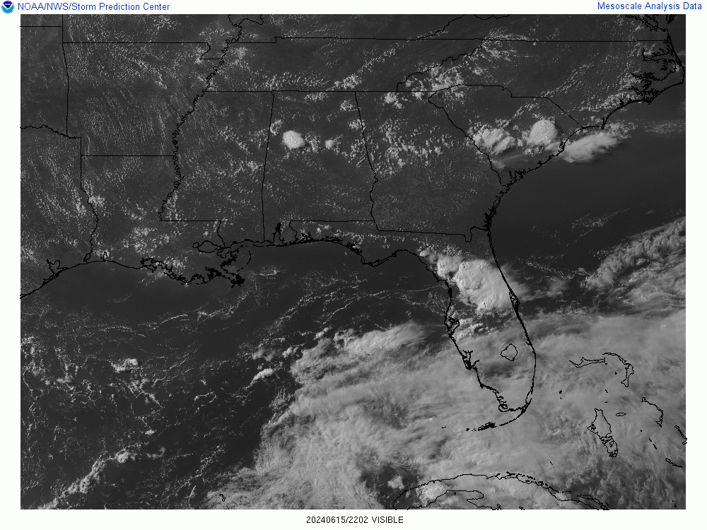
The radar a little after 5 PM is a reminder that no summer day is really immune from a few isolated showers and thunderstorms. The heaviest rain at the moment, the only really organized thunderstorm, is located down in Northern Tuscaloosa County.


You have to go down to South Florida to find any really significant rain around the region though. Summer has come in with a vengeance, even though we're still five days away from the Solstice (this coming Thursday). A ridge of high pressure dominates our weather for the most part, though we do also have a weak frontal boundary stalled across the AL/TN state line and stretching through the mountains of Northeast Alabama.


The ridge of high pressure and heat will continue to be the main story tomorrow. We'll see a High near 95, Low near 70, mainly just a hot and muggy day, mostly sunny skies, will include a minimal 20% chance for isolated rain based on seeing some Gulf moisture and how the radar looked today. But if you get any relief from the heat tomorrow, you're lucky. Since we're not used to the heat yet this summer, I'd be careful staying out in it too long, if you're getting something done outside. After a few weeks of temperatures around 90 or above, I guess we'll be used to it again.


The ridge relaxes a little on Monday, but I still think the models are jumping the gun with how much to lower temperatures, showing more like 90/70. Instead I'm going with more like a High near 93, Low in about 71-73 range, keeping a 20% chance of rain in there.


Let me amend that a little as I look toward Tuesday and start to see the overall model pattern better. Let's have a 30% chance of rain for Monday and bring it back to 20% for Tuesday. Still think Monday's High should be in lower 90's, Low in lower 70's.
And for Tuesday, looks like similar temperatures, might adjust a degree or two as the rain chances are slightly lower with less moisture showing up inland.


The pattern doesn't change all that much on Wednesday, will keep a 20% chance of rain and High in lower 90's, Low in lower 70's.


By Thursday, the ridge builds back over the region strongly enough that we might can take out even the 20% chance of rain. Skies should be mostly sunny, with again, Highs in the lower 90's. Lows should be near 70.


A weak low pressure system from the East may bring us more rain chances Friday. The ECMWF shows this same feature slower (more on Saturday) and further South. Since the model guidance is so unclear, and it's summer around here, I will I'll scrap the idea of taking out rain chances for Thursday, keep the 20% chance in, and also keep that for Friday here, might increase to 30% in case that Low does take a path more like the GFS suggests here, similar timing. High should be near 90 or so, Low near 70.


And will keep the 30% chance of rain for next Saturday, even though the ECMWF balances out what you see from the standard GFS above. The GFS is too wet, the ECMWF is too dry, IMHO. Sometimes in summer around here it's tempting to just throw out all the model guidance and default to climatology and past personal experience, just looking at what the weather's actually doing right now. But they do provide some hints as to what it's going to do. Even when they don't get it right. Expecting a High in upper 80's or about 90 Saturday, Low of 70 or so.

A tropical depression may form in the Southwestern Gulf of Mexico by the middle of this coming week. And even if only a broad tropical Low forms, several days of heavy rain are expected over parts of Southern Mexico and Central America. Some of the latest model guidance shows this affecting Southern Texas. I think more of the tropical models still keep it moving into Southern Mexico. And those are usually more reliable for tropical systems. If a tropical depression forms, it could lead to flooding issues, which can be a threat to life and property more in the terrain of Mexico than when we have flooding up here in Alabama. So if you know anybody down that way, might give them a heads up about that.

Average rainfall totals for this forecast period will only be up to a tenth or a quarter of an inch. Any rain we get is going to be hit-or-miss, pretty isolated, with most of us just staying hot and humid most of the time. Summer has arrived.


No comments:
Post a Comment