6:32 - Let's get a look at this on radar.
Looks like this storm is trying to produce a tornado. And out of respect for the history of today's storms, I would take all warnings seriously tonight and get to a safe place within five minutes of getting a warning.
6:39 - Here is the broad view. For a color code refresher, the red is the Tornado Warning for Lauderdale County. The yellows are Severe Thunderstorm Warnings. And the tan boxes are Special Weather Statements, for a strong thunderstorms, but which are thought to be under severe limits for now. For a thunderstorm to be severe, it has to produce winds of at least 50 knots (58 miles per hour) or hail at least an inch in diameter (size of a quarter).
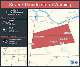
6:42 - And now we have a new Severe T-Storm Warning from about Red Bay up to Russellville and Littleville in Colbert and Franklin Counties.
And SPC issuing some new analysis saying they may need to extend the Tornado Watch into the rest of Northeast Alabama and farther East into Tennessee.
Also noting that while severe thunderstorms and isolated tornadoes are possible anywhere in and close to the watch area, the highest threat for a tornado is currently along the Alabama/Tennessee state line, where some discrete supercells are still being seen. Other places, the storms are trying to form a squall line, though it is a ragged and disorganized one.
That's my interpretation of the latest mesoscale discussion they issued.
6:47 - Finding it difficult to verify how many injuries or fatalities occurred earlier in Tennessee and where. Different sources say slightly different things, and I think for my part, I will defer any further discussion of that until the light of day tomorrow. When things can be sorted out and surveys can be planned for these tornadoes.
Also there are too many Severe Thunderstorm Warnings being issued for basically the same areas within the same counties, just multiple warnings to cover different parts of counties. I'm not going to pass along every single one, because it just becomes a big mess, at least when we've got a Tornado Warning somewhere nearby. Will give priority to any Tornado Warnings and then show the broad view for the numerous Severe Thunderstorm Warnings. I'd still take them seriously though, the damaging winds can be dangerous.
6:51 - Here is the broad view for now. Even in the severe thunderstorm warnings, I'd stay away from windows. And if possible, be on the lower level of a sturdy house or other building, rather than in a mobile home. Of course in the tornado warning polygon there in Lauderdale County, you should take full precautions in a small central room on the lowest floor, away from windows.
6:58 - The tornado warning has been allowed to expire.
7:02 PM - And for now we are down to having more of a threat for damaging winds and some hail in thunderstorms around the Shoals and up into places like Giles County, TN.
Please avoid becoming complacent though. For about the next 4-5 hours, we still have the potential for some thunderstorms to become severe, with this damaging wind/hail threat, and also for a couple of storms to try to produce tornadoes still. It would be foolish to poo-poo that potential when the night is still young.
Tornado Warning
ALC077-100100-
/O.NEW.KHUN.TO.W.0039.231210T0028Z-231210T0100Z/
BULLETIN - EAS ACTIVATION REQUESTED
Tornado Warning
National Weather Service Huntsville AL
628 PM CST Sat Dec 9 2023
The National Weather Service in Huntsville Alabama has issued a
* Tornado Warning for...
Northeastern Lauderdale County in northwestern Alabama...
* Until 700 PM CST.
* At 628 PM CST, a severe thunderstorm capable of producing a tornado
was located near Killen, or 10 miles northeast of Florence, moving
northeast at 45 mph.
HAZARD...Tornado and quarter size hail.
SOURCE...Radar indicated rotation.
IMPACT...Flying debris will be dangerous to those caught without
shelter. Mobile homes will be damaged or destroyed.
Damage to roofs, windows, and vehicles will occur. Tree
damage is likely.
* This dangerous storm will be near...
Lexington around 635 PM CST.
Other locations impacted by this tornadic thunderstorm include Green
Hill, Center Star, Kingtown, and Anderson.
PRECAUTIONARY/PREPAREDNESS ACTIONS...
TAKE COVER NOW! Move to a basement or an interior room on the lowest
floor of a sturdy building. Avoid windows. If you are outdoors, in a
mobile home, or in a vehicle, move to the closest substantial shelter
and protect yourself from flying debris.
Tornadoes are extremely difficult to see and confirm at night. Do not
wait to see or hear the tornado. TAKE COVER NOW!
&&
LAT...LON 3500 8722 3498 8721 3493 8721 3483 8753
3483 8757 3491 8763 3501 8746
TIME...MOT...LOC 0028Z 244DEG 40KT 3491 8751
TORNADO...RADAR INDICATED
MAX HAIL SIZE...1.00 IN
$$
70/DD


No comments:
Post a Comment