Wednesday (High 55, Low 32): Mostly sunny. Seasonably cold.
Thursday (High 46, Low 30): Mostly sunny during the day. Increasing clouds with isolated rain/snow showers possible at night.
Friday (High 40, Low 29): Partly to mostly cloudy. Isolated rain/snow showers are possible - accumulation, if any, is expected to be light.
Saturday (High 50, Low 26): Mostly sunny.
Sunday (High 53, Low 28): Mostly sunny.
New Year's (High 49, Low 30): Partly to mostly cloudy with a 20% chance of showers.
Tuesday (High 44, Low 22): Sunny.
Since we do have snow chances occasionally in the Winter months around here, here is a review of what winter weather alerts mean and how to prepare.
It was overcast during the morning and midday, and then the skies cleared up for the afternoon. The High in Cullman was 52, and our current evening temperature of 41 is our Low so far for this 24-hour period.
That cold core upper Low is apparent even on satellite imagery. Back in the Midwest.
Tomorrow is looking like a mostly sunny day around here, and even at night, I think we can nix the rain chances, just a slight increase in clouds tomorrow night. Should start the day around freezing and warm to about 55 degrees.
It is Thursday we'll have to watch, as some colder air filters into the region before we get the rain from this Low pressure system. Only expecting a High of about 45-46 for Thursday after a morning Low down around 30.
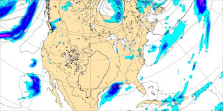
And I started to show the model estimates of timing for a snow mix or changeover to snow Thursday night into Friday, but frankly, the guidance is scatterbrained, even keeps changing the timing of it. Just know that idea is on the table for Thursday night into Friday, some of the rain could change over to snow or at least mix with snow. The rain is expected to be very light, and if we see snow here and there, it will likely be light too, might even be only flurries or a dusting for many places.
It is starting to look more likely that any snowflakes we see will linger into at least the early part of the day Friday. Probably starting the day near 30 degrees again and then only warming to about 40 degrees. So this is a close call as to whether we could see light accumulations, at least in the higher elevations. If we did, it'd probably be mainly along the Cumberland Plateau in Tennessee, much less chance of it in Alabama, even in the mountains. But certainly not impossible for a light accumulation.
Sunshine returns Saturday, and it looks like we'll struggle to get up to 50 degrees, morning Low down in the 20's, probably mid-20's.
Then Sunday, New Year's Eve, another mostly sunny day, High in lower 50's, Low in upper 20's.
Then another clipper system may bring us some rain for New Year's.
But the ECMWF has really backed off on the available moisture with this, so going to keep rain chances on the low side.
Especially since the GEM also makes the precipitation chances look meager.
So I'm forecasting a 20% chance of rain for New Year's Day, Monday, a High around 50 and a Low near 30.
And behind that system, yet another shot of cold air, only warming to the mid-40's on Tuesday after a morning Low in the lower 20's.
If this was all going to be rain Thursday night into Friday, it would only be a trace. Converted into snow, my best estimate is that for the scattered areas in the region that may see a meaningful accumulation, we're probably looking at about a half-inch to an inch for the Cumberland Plateau, then for other places, a dusting to a half-inch. And that's for the scattered spots that do get some accumulation. For most of us, I think some flurries up to maybe a dusting is the most realistic bet.


No comments:
Post a Comment