Wednesday (High 80, Low 51): Mostly sunny. Breezy and warm.
Thursday (High 76, Low 57): Partly cloudy with an isolated shower possible during the day. Rain showers are likely at night.
Friday (High 63, Low 52): Cloudy and cool. Numerous rounds of rain showers are possible throughout the day and night.
Veterans Day (High 60, Low 45): Mostly sunny with a 20% chance of a shower.
Sunday (High 61, Low 47): Partly cloudy with a 30% chance of showers.
Monday (High 64, Low 40): Mostly sunny.
Tuesday (High 62, Low 37): Mostly sunny.
We had a sunny day in Cullman with breezy conditions at times, winds generally from the Southwest today, High of 79 this afternoon, Low of 48 this morning.
We remain in a dry pattern through tomorrow, and then we'll have rain chances that won't break the drought, but may help things along a little bit. A lot of times droughts end with a bang, so if this one can end in several more peaceful systems, can't complain about that.
Winds aloft are more zonal from the West, but as mentioned above, at the surface have been more Southwest.
And those winds have been rotating around the high pressure centered more to our Southeast, over much of Florida and Southern Georgia.
Tomorrow we have a cold front approaching but not close enough to bring any rain. Should be mostly sunny and breezy tomorrow, starting the day around 50 or so, maybe about 52, and then warming to about 80 in the afternoon.
Then Thursday and Thursday night that front drops in our region, bringing rain chances back. During the day we'll probably only see an isolated shower or two, but then at night rain is likely. Daytime High should be in the mid to upper 70's and the Low in the mid to upper 50's.
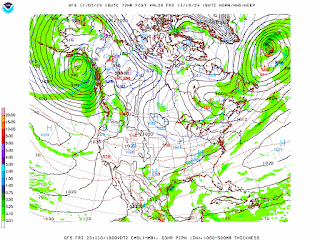
The GFS shows some rain continuing on Friday but moisture being somewhat limited.
The NAM has us good and wet, but as a mesoscale model, it can start to be iffy at 72 hours out.
The ECMWF is closer to what the GFS was showing. And I'm only going to include a 50% chance of rain for Friday. Most of the rain may come overnight between Thursday and Friday, though we'll have about a 50/50 shot of showers throughout Friday as well. Expecting a High in lower 60's, low in lower 50's.
For Saturday, the two main global models have flip-flopped. Earlier the ECMWF was showing rain where the GFS wasn't. Now the GFS is showing lingering rain where the ECMWF has it well to our South and us dry up here. Will allow a low chance, 20% of a lingering shower on Veterans Day, More sun than clouds, High near 60, Low in mid-40's.
For Sunday the models are in a little better agreement for some rain chances, the moisture from that front being slow to kick on through the region. So at this point will include a 30% chance of rain for Sunday with a High of about 60 or so, Low in mid to upper 40's.


Then it does look like clear skies return on Monday as we get Northwest winds aloft and high pressure moving back in. High should be in the mid-60's and the Low down around 40.
Then the high pressure ridge is strong for Tuesday again, so similar weather, but maybe slightly cooler with a High more toward the lower 60's and the Low dipping into the 30's again.
Some forecasts lately I went a little bit "loose cannon" and speculated on the weather for the rest of the month, but that's because I hadn't made a forecast in a while. Trying to keep up with it every day or two is always humbling. The patterns can throw enough curves that are a challenge to figure out during a seven-day period. So especially in a dynamic time of the year like the transition between Fall and Winter, now through about the Winter Solstice, there is not a lot of value in trying to peek at ten days ahead or more. Even if a lot of people do it. It can be fun sometimes, but it's probably better to stick to the next week ahead and try to get that as accurate as possible instead of wasting energy on stuff probably nobody is going to get right in a forecast, because it's too far in the future.

Most of us will see about a quarter-inch of rainfall from Thursday and Friday, and then whatever leftovers we may get over the weekend, a little extra rain possible. A few isolated spots in the region could see more like a half-inch. And for especially West Tennessee, amounts closer to an inch of rain are within the realm of possibility. So this isn't going to get us out of the drought, but every little bit helps.


No comments:
Post a Comment