This mesoscale convective system that came from Missouri and Arkansas has prompted a Tornado Watch for Northeast Arkansas, Western Tennessee, and Northern Mississippi. The National Weather Service in Memphis considered negotiating this down to a Severe Thunderstorm Watch, but found enough wind shear/helicity to justify keeping a Tornado Watch.
12:37 AM Thursday - Looking at radar trends, the storms may mostly stay under severe limits tonight. But we could see an isolated severe storm or two.
12:49 - And there is a thunderstorm that has gone severe near Lexington and Decaturville in Tennessee.
12:51 - And that just got extended into Wayne and Lawrence County.
12:53 - This does include the cities of Waynesboro and Lawrenceburg. And this looks more like a squall line (QLCS) than an MCS.
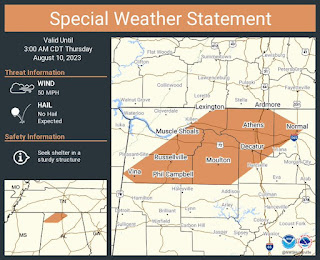
1:22 AM - Now a Special Weather Statement as the storms move into Northwest Alabama. Wind gusts are expected to stay just below severe criteria.
1:24 - Here is a radar update.
1:41 - Looks like SPC considered a watch while I was distracted. But by now I'm not sure what purpose it would serve, with the line already working into Alabama. For now the only severe stuff is up on the Tennessee side.
1:57 - Once again it looks like these storms are producing strong winds, but staying under severe limits as they push further into Alabama.
And the warnings have been allowed to expire in Tennessee as well. So far we are not having any severe weather problems for right now and no flooding problems.
2:28 AM - And now we have another special weather statement mainly up in Southern Middle Tennessee, includes Winchester.
And whoa, we just had a close lightning strike here in Cullman. This laptop just went on battery power in a hurry.
Let's look at the radar.
Interesting, those storms are forming ahead of the main line. This is a funky setup for an August night.
2:38 - Especially seeing evidence of strong winds up around Athens.


.png)


No comments:
Post a Comment