Thursday (High 81, Low 64): Mostly cloudy. Numerous rounds of showers and thunderstorms are possible.
Friday (High 87, Low 63): Partly cloudy. Widely scattered showers and thunderstorms are possible.
Saturday (High 90, Low 64): Partly to mostly sunny. An isolated shower or thunderstorm is possible.
Father's Day (High 86, Low 66): Mostly cloudy with a 50% chance of thunderstorms.
Juneteenth (High 84, Low 68): Mostly cloudy with a 50% chance of thunderstorms.
Tuesday (High 85, Low 66): Partly to mostly cloudy with a 40% chance of showers/thunderstorms.
Wednesday (High 86, Low 65): Partly to mostly cloudy with a 30% chance of showers/thunderstorms.
So we had a stormy one in the Tennessee Valley today, unusually stormy for this time of year. Looks like we had a High of 77 and Low of 66 in Cullman today.
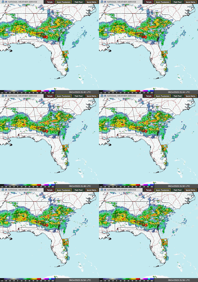
And look at those storm reports. We had trees down in Winston, Blount, and Walker Counties, even a tree down on a vehicle in Blount County along Red Valley Lane at Village Springs. Some hail around here too, but the really big hailstones were further South and back in Mississippi, where some places saw hail up to the size of golfballs, baseballs, or larger. There were two tornadoes reported early today in far Southeast Alabama, then three reports of tornado touchdowns as the storms continued into Southern Georgia, and also a possible tornado touchdown out in Texas. It has been a busy weather day.
And there are still severe thunderstorms happening in Southern Mississippi, Alabama, and Georgia. This surface map is probably out of date as far as having this frontal boundary a little farther North still than where the radar and satellite imagery suggests.
That front is expected to push South of the area over the next couple days. And that strong upper-level Low should finally move off into New England.
Low tonight may get down into lower 60's again, about 64, and then the High tomorrow probably about 80 or so. Might go with 81-82 because I don't think it'll be rainy or stormy all day. But overall we'll see more clouds than sun around, and about a 50/50 chance of any one spot getting a shower or storm. May have numerous rounds of rain and thunderstorms.
The threat of having any severe thunderstorms in Central and North Alabama tomorrow is looking marginal. If we get something like that, it should stay isolated. And I think that will also be the case overnight tonight. I doubt we see any more severe up in North Alabama tonight, but if we did, think it would be an isolated storm or two that managed to get out of hand. But the conditions really do not favor severe storms the rest of tonight. Those conditions are in place further to our South.
Then on Friday, any showers or storms that fire up from leftover boundaries should be much more scattered in nature, about a 30-40% chance of rain, High back up to about 86-87, Low in the lower 60's, about 62-63.
Then Saturday the rain continues to be more isolated, about a 20-30% chance of any one spot getting wet. High may climb all the way to 90, Low in mid-60's.
Going to bump rain chance back up to 50% for Father's Day, Sunday. High in mid-80's, Low in mid-60's.
And then I hate to be the bearer of bad news for two holidays in a row, but Monday, Juneteenth, is looking like need to just say "likely" rain chances. And this setup with this system really favors a mesoscale convective system that would approach from the Northwest and bring us more chances for strong storms, that could even reach severe limits. So our pattern is staying pretty active right now. This might help us out, all the rainfall, later on in July and August, if we have some more boring but really sultry weather periods like we do some years. That rain stays in the soil and keeps heat from getting excessive sometimes.
High in lower-to-mid-80's for Monday, Low in upper 60's is a good estimate.
Then for Tuesday and Wednesday, will slowly taper the rain chances down to about 40-30%. Highs should be in mid-80's and Lows in mid-60's.
With as unsettled and dynamic a forecast a this, not even insulting my readers' intelligence by trying a 10-day forecast. I mostly do that as a gag about once a week anyway. Because it cracks me up when I see TV stations doing that. One of the better stations does only give a vague forecast for days 8-10, like a wide temperature range and graphics that vaguely hint at trends. Vaguely hinting at trends is usually the best you can do beyond a week in advance.
We could see an average of 2-3 inches more rainfall totals over the next seven days. And I think I'm going to blanket Sunday and Monday with a 50% chance of rain for now. If that needs adjusting upward, think I'll post another forecast tomorrow or tomorrow night updating it.
Trying to forecast this weather has been a humbling experience lately. If you have plans Sunday or Monday for the holidays, especially if it's late Sunday into early Monday, please do keep an eye on the possibility of that mesoscale convective system, since that could bring some organized damaging wind potential, depending on how it plays out. Sometimes those things don't amount to much, but considering the timing, I'd keep it in mind, the potential.


No comments:
Post a Comment