(Forecast)
Wednesday (High 80, Low 54): Mostly sunny.
Thursday (High 82, Low 56): Sunny.
Friday (High 81, Low 58): Partly cloudy with widely scattered showers and thunderstorms possible.
(Extended Outlook)
Saturday (High 79, Low 59): Partly cloudy with a 30% chance of showers/thunderstorms.
Sunday (High 80, Low 57): Partly to mostly sunny with a 30% chance of showers/thunderstorms.
Memorial Day (High 83, Low 56): Mostly sunny with a 20% chance of showers/thunderstorms.
Tuesday (High 86, Low 60): Mostly sunny with a 20% chance of showers/thunderstorms.
(Tea Leaves Territory)
Wednesday (High 88, Low 64): Mostly sunny with a 20% chance of showers/thunderstorms.
Thursday (High 89, Low 67): Partly cloudy with a 30% chance of showers/thunderstorms.
Friday (High 88, Low 68): Partly cloudy with a 30% chance of showers/thunderstorms.
Boy, I sure blew this last forecast. Instead of widely scattered showers throughout today, we had a mass of rain through the early part of the day, then clearing in the later parts of the day. The models were right this time, not climatology or my personal experience/hunches.
We had some level of rain, fog, and/or mist in Cullman from the morning hours up until about 4 PM this afternoon. It was occasionally breezy, but overall the winds were light with this activity. We saw a High of 70 and a Low of 61. Jasper saw a High of 72 and a Low of 63 today. They dealt with more clouds than rain the bulk of today. And it looks like the rain was over with during the morning hours for Haleyville too, where they had a High of 71 and Low of 62.
Not much rain showing up on the radar at this hour.
Most of the thunderstorm activity has shifted down to the Gulf Coast and mainly in Florida.
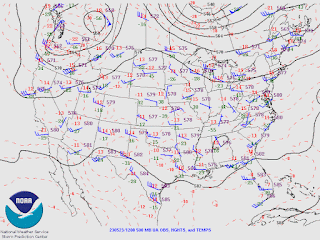
The low pressure has become aligned with a front stalled down there. Meanwhile high pressure is settling over much of the country, and an omega blocking pattern of high pressure is expected to set up later this week.
If you notice on the 500 millibar map forecast for tomorrow by the GFS (top graphic), there is a trough over the Western U.S., a ridge of high pressure through the Central U.S., and then more troughing as you get to the East Coast. We'll be mostly sunny with a High near 80, Low near 54.
Then with high pressure staying in place influencing our weather on Thursday, we stay sunny, High of about 81-82, Low of about 56-57.
Then on Friday, a low pressure system is expected to form along the southern end of that trough over the Eastern CONUS. Looks like only enough to introduce a 20% chance of showers/thunderstorms again, High still near 80, Low edging into upper 50's.
Basic pattern holds for Saturday.
And will keep the same forecast for Sunday to be on the safe side, thinking of climatology, though moisture levels may be coming down locally by then.
And actually the latest run of the GFS is making it look like isolated showers/storms could hang around Monday too.
And on Tuesday.
Glancing at the ECMWF, it shows potential of scattered rain some days. And I think I'm going to gear this forecast more toward climatology, keeping a 20% chance of rain in for the extended. I think Friday and Saturday deserve a 30% chance of rain. The general trend should be a warming one and less rain as we go along and get into next week. But I'm not sure if I'm going to totally cut out rain chances for any part of days 4-7 here.
Since a lot of TV stations are doing 10-day forecasts again these days (not a new idea, I've seen some stations do that and then drop the idea in years past), I'm going to show that I too can have a go at reading tea leaves.
All I really see evidence for is increasing rain chances a little on days 9 and 10, probably only to 30%. And adjust temperatures according to what would be expected with that this time of year. Since we will be into the month of June by this time, so into summer (in terms of meteorology, though not astronomy), it makes sense to defer to climatology and one's own personal experience of same. You can't take the models literally, especially this far out. Still, if there is one time of year around here that a 10-day forecast might have some accuracy, summer is it.
Hope you enjoy all the good and bad of summertime, whether I keep this blog up periodically or not.
Oh and by the way, that tropical wave in the Atlantic fizzled out as expected.


No comments:
Post a Comment