Monday (High 63, Low 39): Sunny and breezy. Patchy frost possible in the morning.
Tuesday (High 70, Low 38): Patchy frost possible in the morning. Partly to mostly sunny during the day, then scattered rain showers possible at night.
Wednesday (High 69, Low 51): Rain showers likely, off and on, throughout the day. Overcast.
Thursday (High 67, Low 54): Rain likely.
Friday (High 70, Low 53): Partly cloudy with a 40% chance of showers.
Saturday (High 72, Low 49): Partly cloudy with a 30% chance of showers/a thunderstorm.
Sunday (High 71, Low 47): Partly to mostly sunny with a 20% chance of a lingering shower.
We have a frost advisory tonight for Tennessee counties and places like Huntsville and Muscle Shoals up close to the state border.
At 8 PM we are overcast in Cullman with a temperature of 48 degrees. The dewpoint is 37, making the relative humidity 66%. Winds are from the North at 3 miles per hour. The pressure is 30.14 inches and steady. Overall we had a mix of sun and clouds today, a few breezy periods, a High of 57 and a Low of 43. In Jasper the High was 61 with a Low of 46. Haleyville saw a High of 55 and a Low of 42. The clouds were a little more persistent in Fort Payne today, and they saw a High of 60 and Low of 43. Seems like their winds had a westerly component more often than a lot of these other sites too. If the observations from Decatur are accurate, they only got to 53 degrees today, Low of 43 this morning. I think that's right, was just on the lower end of temperatures, and it seems like their site was down or having difficulties within the past couple weeks. Looks like that data is correct though. At the Huntsville/Madison County Airport, the wind observations are strangely missing. Maybe because my niece up that way got chastised for excessive references to windbreaking during this past week. Maybe everybody took it too seriously. Okay, but their High today was 51 with a Low of 42. Fayetteville only made it up to 48 with a Low of 41. And it looks like those were also the High/Low temps for Winchester.
We have some light rain showers moving through at this hour. Thanks to my bro for helping me get and set up a new phone that supports Radarscope, but no need to use it this go-round, no major storms going on around here. I still can't get it to work on desktop and guess if I do use it I will go back to e-mailing the images to myself. It's still really neat to have on a cellular device. I like that other product, Radar Omega, and may use it again in the future. Trying to cut back on monthly subscriptions for the time being.
The only really big storms right now are down in the Gulf of Mexico, South of Louisiana.
Looks like that is associated with an area of low pressure to the South of the main stationary front we've got stalled out around about Montgomery down through Biloxi and New Orleans.
Tomorrow we have high pressure moving in from the Northwest. We'll have a Low of about 39 tonight,a and then sunny skies tomorrow with a High near 63. The northerly breeze will make much of the day feel cooler than it really is though.
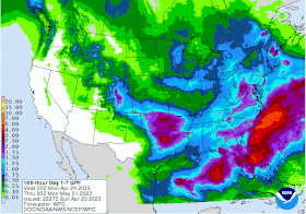
That high pressure moves off to the East/Northeast on Tuesday, but we'll have another dry day, won't get any more rain (associated with a shortwave trough approaching from out West) until Tuesday night into Wednesday. Winds should be lighter on Tuesday, and overall I think the day is partly to mostly sunny for most of us. Clouds will increase in the evening of course, with rain chances coming back overnight into Wednesday. But overall another dry and mostly clear day. Winds more like 5-10 miles per hour and shifting more to an Easterly direction as the pattern changes. High should approach 70, Low near 40 again.
The models diverge a little for Wednesday's weather. And I have not been keeping up with the weather for about the past week.
The NAM is a lot more conservative with the rain chances than the GFS, but once you get out this far, it starts to be less reliable anyway.
The ECMWF tends to do better at this time range, and is much more in line with what the GFS is showing. I'm playing catchup with this forecast package since I've been out of the loop. I think the GFS has a good handle on this one. As the Low pressure system moves through the Plains, I think we will get plenty of rain in the Southeast. Rain should be scattered Tuesday night but then widespread on Wednesday during the day. Low should rebound to about 50, High staying in upper 60's.
If anything Thursday looks even wetter. Though the European did show a slower timing of the second wave of rain, another shortwave trough coming in with this main Low pressure system. Should have a High near 70 again, Low in the lower 50's.
Then as we get toward the end of the forecast period, next Friday, the GFS may be getting in too big a hurry kicking this system through here.


.png)


No comments:
Post a Comment