Monday (High 72, Low 59): Rainy. Windy.
Tuesday (High 75, Low 48): Sunny. Cool in the morning, mild in the afternoon.
Wednesday (High 77, Low 54): Partly cloudy with a few isolated showers possible during the day. Clouds increasing and rain becoming likely at night.
Thursday (High 73, Low 61): Thunderstorms likely - some possibly severe.
Friday (High 62, Low 53): Gradual clearing.
Saturday (High 55, Low 36): Sunny.
Sunday (High 58, Low 30): Sunny.
A wind advisory has been issued for tomorrow.
At 2:30 PM we are partly cloudy in Cullman with a temperature of 66. The dewpoint is 61, making the relative humidity 83%. Winds are from the Southwest at 6 miles per hour. Visibility is 10 miles. The pressure is 30.05 inches and falling. Jasper is mostly sunny and 72 with calm winds. Mostly cloudy in Haleyville and 69 degrees, southwest winds at 10 mph.
Elsewhere around the region: Fort Payne is overcast and 62. Gadsden is mostly sunny and 69. Overcast in Muscle Shoals, they are at 64. Atlanta has west winds gusting up to about 25 mph, they are mostly cloudy and 75. Birmingham is mostly cloudy and 70. Nashville is overcast and 59. Decatur observations have not been available lately. Overcast and 62 in Huntsville with calm winds. Memphis is mostly cloudy and 59. Tupelo is partly cloudy and 72. Tuscaloosa is sunny and 76.
It did get a little foggy this morning, and our Low in Cullman was 52.
Our High this evening will probably get up to about 69.
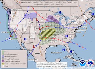
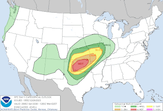
The big story nationwide today, even more than the extra snow happening in the Pacific Northwest, is the derecho event capable of widespread, significant damaging winds that is trying to get going in the Great Plains.
Initially supercells are expected to form in the general vicinity of Southwest Oklahoma, then merge into a squall line pretty quickly. And most of the state of Oklahoma is at significant risk of widespread damaging winds with these storms. That risk clips parts of Northern Texas and also extends into Southern Kansas and into parts of Missouri.
And they are getting ready to issue a Tornado Watch for this afternoon and evening.
Tomorrow that front will push Northeast, and we will be windy and rainy around here, may not even see much thunder or lightning.
The severe weather threat will stay well to our North, up in the Ohio Valley and up around the Great Lakes, mainly a risk for damaging winds, although an isolated tornado could happen somewhere in that broad area outlined by SPC.
Around here we could still see some sporadic damage from high winds unrelated to thunderstorms. Winds could gust up to about 50 miles per hour here and there, at times. Generally will have winds more like 25-35 mph, but probably some higher gusts in spots.
Should see a High near 72 and Low near 59. Just a lot of wind and rain.
Tuesday we will catch a break in the action with sunny skies, High near 75, Low near 48. The moisture will get out of here soon enough to allow good radiational cooling going into Tuesday morning.
Wednesday we are still in between systems, and a mix of sun and clouds, rain chances staying on low end like 20-30% chance during the day, but then rain becoming likely at night. High should be in mid/upper 70's and Low rebounding quickly into mid-50's.
Friday looks like gradual clearing through the day after what may be a pretty stormy night, breezy conditions staying around even if we see some sunshine by end of day, High back down to lower 60's and Low in lower 50's.
Then Saturday as High pressure swiflty moves back into the area behind the strong front, should only see a High in the mid-50's and start the day in the mid-to-upper 30's.
Then sunny skies again Sunday, similar High temp, don't want to get carried away for Low temp but the MOS is showing 29 on the GFS. Will forecast a Low of about 30-32 for now.
And we could see rainfall totals up to 2-3 inches over the next week. So some places might have a flooding concern along with any severe storm potential we have toward the end of the week. And then of course, high and dry for the weekend, and feeling like Winter again.


No comments:
Post a Comment